


SkyChartsPro app for iPhone and iPad
Developer: SkyCharts LLC
First release : 01 Apr 2010
App size: 63.69 Mb
Still works on all iPad models! (including iPad1)
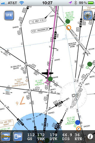
Fastest in flight usage of all iPad EFBs- simply double tap on ANY airports to bring up A/FD and approach plates for that airport. Charts have track up and a detailed flight info strip is provided.
SkyCharts does not *yet* support:
* TFR and radar.
For answers to many common questions please view the FAQ: http://www.skycharts.net/faq.html
For more information, please see the webpage at
http://www.skycharts.net
Full description:
Moving map with current IFR/VFR/TAC/FLY/HIFR/HELI/GCW/GOM/WAL aviation charts. Maps are now overlaid on ONC charts for worldwide coverage.
DOUBLE TAP on map to view A/FD and approach plate. Map has VFR/IFR/LIFR color-coded METARs, with orange TAFs.
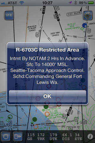
SUA airspace information is also available.
No service? No problem! Download charts and plates for offline usage.
Flight plan and navigate using the ICAO airport/navaid database, or manually enter lat/longitude way points.
Features:
* Fast zoom/scroll of included charts using standard gestures.
* Fast download of charts for offline usage. Charts are selected on a region basis, 7 for CONUS and 2 for Alaska. The ENTIRE CONUS only take about 1hr to download! Downloading all takes about 5GB of disk.
* Flight planning with fuel and distance. Example: KUAO RAWER UBG MCCOY KSLE
* Automatic waypoint sequencing
* Navigation computes GS, TRK, DTK, DIS & ETE to current waypoint.
* METAR/TAF color coded dots according to ADDS: http://www.skycharts.net/?page_id=421
* Double tap on airport to select A/FD and TPPs/IAPs to view.
* Call ASOS/AWOS/ATIS once an airport has been selected.
* Huge built-in navigation database, with all 20,000 airports, 45,000 FAA IFR/VFR naviation fixes and 2,100 FAA VOR/ADF fixes.
* XPlane flight simulator tracker. Follow the directions here: http://www.skycharts.net/?page_id=228
* Location tracker. Enable the BreadCrumbs setting in the system settings and your friends can check your current location. More details here http://www.skycharts.net/?page_id=365
* See current chart cycle and expiration date.
* Map in portrait or landscape mode
* Toggle track up or north up. If you always use north up please set change the preference for SkyCharts for even faster viewing.
* Airplane shows direction of flight when north up is selected.
VERY, VERY IMPORTANT, PLEASE READ!!!
**BEFORE** trying to use SkyCharts offline, please download the region you will be using by pressing the i button. This will download and save the charts and approach plates on your device.
For fast response to all questions, comments or suggestions, please email [email protected]